


The Middle-Aged Hiker
Chapter Twenty-One
The Canyon Guide Imposter Trek
"Noise is in the ear of the beholder."
October, 1988. I'm taking a 3-month leave of absence from a tedious job in Philadelphia where I type apocryphal letters for a jumbo hamburger-oriented corporation and moonlight as an advertising gimmick named Mac Tonight. I'd wanted to resign, but the personnel folks think I should take some time off to think things through. The deciding factor is they'll let me keep my voice mailbox.
So, still covered with minimal medical insurance, I head west. To corporate headquarters in Oak Brook Illinois, to see some lower echelon corporate employees with whom I've occasionally enjoyed good phone. But in person, they're wary of me, fearful my admittedly unrestricted shenanigans might jeopardize their hamburgeoning careers. Their shoulders grow increasingly chilly, and offers of overnight accommodation are nil. So, I leave, continue west.
Not a problem, really, I was going this way anyway. I'd arranged to meet Dennis in Boulder, and from there lead him down some of my favorite roads, eventually to Grand Canyon to hike the Hermit Loop. Glad for the interstate change--80 instead of 70 or 40--I zoom through Illinois and Iowa, pausing 200 miles past Davenport for a car-nap, contortionist style. Continuing through Nebraska and the flat part of Colorado, I soon realize these roads're just as tedious as all the rest.
I arrive in Boulder to a change in plans. Instead of leaving his car safely parked at a friend's house there, he'll follow. His friend's young daughter, looking for attention, smashes a tomato on my head, underlying the tension in town. But I'm still hungry, so we hit a cheap restaurant, then hit the road. It's 9:30 and I'd prefer a nap, instead we go up and over the Rockies to Grand Junction, all the great mountain scenery lost in the pitch nightness. We follow one another's exhaust for a while, then he speeds ahead to the motel rendezvous, which I soon discover I'd given him inaccurate directions to. So I get there first anyway.
The next day, a Saturday, we drive to Arches National Park in eastern Utah, where I discover--by the enormity of the crowds--that it's a holiday weekend (Columbus Day ... see?, you didn't know either). The campground is full, so after clambering around a few arches and I run over a dog, we decamp to a Moab motel.
Next morning, my eye feels like I wiped it with glass shards so I check into the local hospital emergency room, emerge an hour later with a prognosis of conjunctivitis, an eyepatch that covers half my face, a tube of ointment, and a bill for $111 (Sunday morning special). Against the doctor's advice, we drive to the Grand Canyon south rim, get an $8.00 campsite confirmed by Ticketron, pitch the tent, heat some dreary packaged goods on the campstove. Sounds easy, but I'm stumbling around in the semi-darkness in a monocular fog, no fun,
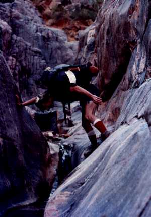
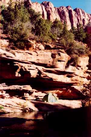
Monday, my depth perception, normally pretty bad, is now terrible, and I rip away half of the eyepatch. My sight doesn't improve, but the chances for facial tanning do. Determined to get to the bottom of things, today's example being Grand Canyon, we go to the Backcountry Reservation Office, score a Hermit Loop permit. Then we drive one car to Hermits Rest, start down. But not until I spend 30 minutes rearranging my backpack. The Hermit Trail is just as rocky and unpleasant as always, but now I have a new person to complain to, makes the grind a bit more bearable. Suddenly an explosion of birds (what kind? how should I know, they were just birds) blasts past us, heading down. It's eight and a half hard miles to the river but Dennis doesn't begin to get downright uncivil till the last hour. After numerous stubbed toes and back strain, we reach the river in the late afternoon, find a campsite, collapse. A brief shower cools us, helps get the sand into absolutely everything and jam the tent zipper, as it always does at Hermit Rapids. I remove the remainder of the eyepatch, and in so doing transfer the conjugal germs from eye 1 to eye 2. Fortunately, the first affected eye begins to clear as the second one blurs.
Tuesday, on to Monument Creek. Back up the Hermit Rapids Trail to the Tonto, then east for a few hours, pretty easy by Canyon standards. We forego the tent and its cranky zipper and sleep on The Point (you'd recognize it if you saw it). Dennis wonders if there's a route down to Granite Rapids by following the drainage of Monument Creek. I assure him there isn't.
 Down to Granite Rapids
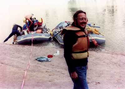
Wednesday, we follow the drainage to Granite Rapids, an easy hour away. A great place, a clean, sandy beach, probably a good campsite for rafting trips. True, as several land to scout the rapids while we're there. One group arrives late in the afternoon, decides to camp for the night.
Thursday, to appease us for the raucous they made during the night, the rafters offer us a lift through the rapids, which we eagerly accept. As the rafts pull out into the current, I watch an enormous raven alight next to our backpacks, ready to claim the contents should we not return. The white water excursion is a 35-second adrenaline rush, and not an easy one, as two of the six boats flip. But it whets our appetite, and we wait around for more boats to chaperone us through the rapids. When none show up by late afternoon, we clamber back up the hill to Monument. Our campsite is underneath a rocky overhang with a natural chimney leading ... where? We climb up the chimney, as probably scores have done before us, and emerge onto the shelf above. Nice view! Later, more food, more ointment, more sleep.
 An Amateur
Friday, eight miles to Horn Creek. En route, we see thunderheads in the sky ahead, then lightning. We hurry to beat the storm, which seems to be pounding the inner canyon around Phantom Ranch (10/14/88, you could look it up). By the time we set up our tent, the storm's fury is spent, and calm again returns to the Canyon. That is, until we try to find a route down to the river. Without a 30' rope, there isn't any. Dennis makes a note to bring one next time.
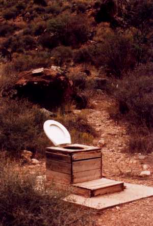 Horn Creek Toilette
Saturday, it's mostly flat and easy to Indian Gardens, 53 minutes, there's plenty of water and shade, but the restaurant smells from the rim beckon. Just under three hours later, we're there, but just barely. We collect the car at Hermits Rest, then I stop by the Grand Canyon Clinic for an eyeball appraisal, but they want $100 cash down (Saturday prices). I decline, and we drive to a ratty Flagstaff motel.
Sunday, we amble aimlessly around Flag, tour the Lowell Observatory, then head north. It's late, we cross Glen Canyon Dam in the dark, on and on through desolate southern Utah, find a motel in Kanab.
Monday, still sick--it's more than conjunctivitis, see--I check in to the Kanab Clinic, get a $45 antibiotic prescription. We drive to Zion National Park, now a $5.00 fee area, great drive-through scenery notwithstanding, then on to the northern corner for a backcountry permit to Kolob Arch. We hike down a well-defined trail for four miles--a piece of cake compared with last week's jaunt--find a lovely sandy spot underneath an overhang four feet from a creek. In fact, it's two miles away from our intended campsite (so much for our topological map skills).
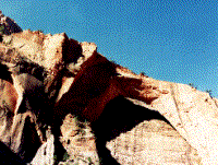 Kolob Arch
Tuesday, no matter, it's beautiful, serene and all that, and we stay an extra day, hiking in the morning to Kolob Arch, a good arch but not a great one. Plus, no easy trails up to that baby.
Wednesday, a leisurely charge back up the trail, a clean-up at the backcountry ranger station, then I suggest a change of pace: Las Vegas, a mere four hours downwind of the campsite. The neon, the noise, the neverending nightlife. We descend upon the all-you-can- eat buffet at Circus Circus: $2.69, 48 selections (note, not all edible), a deal. Then we repair to a motel with slot machines in the lobby, and later a cruise down the garishly illuminated Las Vegas Strip. Rocks? Canyons? Solace? Who needs 'em?
Thursday, actually we do, and we drive north again on I-15 past Zion to Cedar Breaks, a National Monument at 11,000' elevation. Cool here in the winter. Our road break lasts but an hour, then we're back on the road east through the northern tip of Bryce Canyon National Park, just passing through. On and on along Utah Route 12, my choice for the most scenic paved road anywhere. At the tiny town of Boulder, the road veers north. But we continue east onto Burr Trail, a 69 mile long dirt road that cleaves even more spectacular canyon lands. At dusk, we find a wide spot in the road--literally--and camp. We set up the tent, cook some food, listen to the World Series in stereo midway between the car radios.
 LaVerkin Creek Tent Site
Friday, this is a great road--though not in wet weather, when travel is difficult and unpredictable--it follows the contours of slickrock canyonettes, dips into streambeds, wends its way amongst gigantic monolithic hoodoos. Its rutted, washboard surface dictates a low speed limit, the better to see the countryside. Even at a careful 20 mph, the car shudders and shakes, acquires new long-term rattles. After a few hours of this, we enter Capitol Reef National Park, another land of twisted landscapes, encounter the lumpy Notom Road from the north, follow it 40 tortuous miles to pavement. Some hundred fifty miles later--sometimes they ain't no way to git from Point A t' Point B in these parts--we reach Moab. The Southern Utah Wilderness Alliance, of which I'm a member, is holding its annual "round-up" at a nearby ranch this weekend. I joined the group because it opposes the paving of Burr Trail. Still does. Even with chronic Honda body rattles, so do I. Anyway, Dennis pastes up an apocryphal PAVE CAPITOL REEF flyer, we xerox 50 copies, leave them in conspicuous piles, they're ignored. Later we set up our tent in an adjacent field for the night.
Saturday, Dennis splits for the east coast, I join other SUWA folk for breakfast as they begin their mostly tedious prepared talks. In the evening a dreadful songwriter strums his gee-tar and sings his plaintive songs. An interminably long but utterly fascinating slide show of the Colorado Plateau follows, followed by tent dreams.
Sunday, I accompany half a dozen others on a day hike up Mill Creek near Moab to see some Anasazi pictographs which've been used as target practice. Eventually, duty calls, and I head back to town to do laundry. Midway through the spin cycle, I decide to drive to Canyonlands, get there after dusk. The park isn't yet a fee area, the campsites are all free, and the park has yet to be overrun by tourists in RVs--my kind of place!
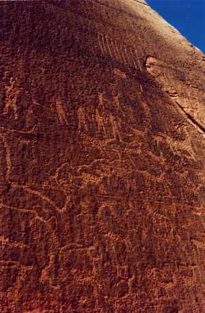 Moab Rock Art
Monday, I hike to the overlook of the confluence of the Colorado and Green Rivers, 5½ miles, terrific view, not for the faint of heights. Then a leisure stroll back to my campsite for a front row seat for the full moon's rising, hopeful the event will inspire a tune. Indeed, my head fills with pounding music as the great, glowing globule ascends over the distant jagged canyon rim. Unfortunately, the music's already been written by Gus Holst.
Tuesday, another dayhike, this one along the Peekaboo Trail where I outward-bounded last year. I hike through heavy sand for a while, finally approach the trailhead. Four hikers are there, cooking donuts. They offer me one. I ask them where they're from. Outward Bound, they reply. Hmm, you know a guy named Denis Luján? He's our instructor, they reply. Hmm, think you'll see him soon? Yeah, tonight, at the end of our Hike-Off, they reply. Look, here on the topo map, right at this campground. Hmm, a mere quarter mile from my own campsite. Well if I die before I get there, kindly give him my card. John Q. Public! You're John Q. Public? The Spam Man? Ahh, so my reputation precedes me. Meanwhile, on to more scenic locales. I head towards a horizontal arch called Paul Bunyon's Potty but can't find it (note: it's directly above my head, but I don't look up). No matter, down the trail a few more miles is Tower Ruin, a former Anasazi condo, well worth the two hour slog through the sand. Later, I assemble my fishing rod, hang an extra Spam tee-shirt from the end, strap a Casio keyboard to my backpack and select the bossa nova auto-rhythm, and pay my respects to the Outward Bounders. It's a great entrance.
Dawn, the Bounders begin their traditional marathon run through the Canyonlands flatlands and I head on down the Peekaboo Trail, having abandoned it yesterday. It's an easy-to-follow route that follows cairns up and down slickrock and around precipitous drop-offs. Unlike last year, I linger, enjoy the scenery. Later, another fantastic moonrise and another mediocre dinner selection.
Thursday, the Outward Bound crew packs up and leaves; me too. I drive east to Dove Creek, Colorado, notorious as the pinto bean capital of the world, and on to Mesa Verde, with its spectacular cliff dwellings but overtaxed interpretive rangers. No camping permitted in these condos, but at least the carefully managed tour allows us daytime access. I stop in Cortez for a restaurant meal. Confirms my belief: don't eat in Utah restaurants. Go on a diet or practice fasting or get take-out from Arizona or Colorado. I drive west again to Natural Bridges National Monument in Southern Utah, but it's late and all the campsites are filled. I turn around again, pull into a turn-out just outside the park boundaries, attempt another carnap. Actually, it's not the improbable shape in which I bend my body but rather the two cups of Cortez coffee that keeps me away all night.
Friday, back inside Natural Bridges. I cook some oatmeal, hike down to a couple of the bridges. Easy, maintained trails, good vistas. But I'm antsy, eager to be elsewhere, so I leave. Back on Route 95 past Cheesebox Mesa, over the Colorado River, heading northwest. I drive through the paved part of Capitol Reef, then over Boulder Mountain, south to the western terminus of the Burr Trail, where I meet a SUWA honcho coming out. He recommends nearby Salt Gulch for a supremely satisfying hike, but it's late, so I drive west towards Bryce Canyon, the road supremely satisfying in its own right. The Bryce campground is, surprise, full, so I leave, drive down a Forest Service road to a campsite I discovered eight years ago. But the forest has changed: from tall shafts to stumps and scrub, all the good wood yanked out by greedy tree farmers. Dusk now, gotta find a spot. I pitch the tent in an open area not too far from the car, hoping to deflect the gusting wind. Drift off to sleep to the accompaniment of howling wind and coyotes.
29th, early morning, cold, I hear the sound of cattle, not far and closing. Why, this isn't a forest glade after all, it's grazing land, and the cows are hungry and on the hoof. I pack up the frozen tent with frozen hands, drive back to Bryce, hike a couple of easy, well- maintained trails, memories of past journeys here now strong. The weather forecast is for snow, no thanks, there's plenty of that back east. So I drop from Bryce's 8,500' elevation to Zion's 5,000' elevation, then drop another thousand feed to that campsite of a week ago, where more moderate temperatures finally thaw out my tent. And me.
30th, I have a two-day backcountry permit but only a one-day supply of food. I hike out, planning to resupply at Cedar City and return. But I note the Glen Canyon Recreational Area in Nevada on the map, decide to go there instead. A mistake. There are no free campsites and no places to hide. I head back towards Zion, but darkness is fast falling; I'll never make it in time. At Saint George, I drive to Snow Canyon, a dozen miles up the road. But it, too, is a reservation-only RV park, no place for tents. All this indecision on the road and subsequent dead-ends are beginning to annoy me. I head south again, give up, pull over an hour outside of Las Vegas.
21st, oh wow, I should have come straight here. I get the car's oil changed, then wash it--the car, not the oil--later decamp to Palace Station Casino, a great $25 rest area. Then back to the Circus Circus buffet, cautiously avoiding the strange pull of the slot machines. Nothing gambled, nothing, um, gambled.
1st, I fetch Jane from the incomprehensibly modern Vegas airport, regale her with yet another buffet meal, assure her that Vegas must be seen at night, swing another night of pure Palace entertainment.
2nd, in the morning, as we prepare to drive off, I notice black fluidy stuff leaking from the car. The local Honda dealership elicits $150 from the travel fund, but at least the black fluid is back where it belongs. Just after noon, we head north towards, surprise, the Kolob Arch trail, as I figure there's just enough time to make it to the campsite before dark. Unfortunately, I fail to take into account changes in the time zone plus an end to Daylight Savings Time. Consequently, we hike the last quarter mile by flashlight.
3rd, back up the trail, feels like old hat by now, though my old hat feels like worn out cotton batting. West now, through Utah desert scrub to Nevada, twice wading through herds of cows and sheep in the road. We ascend to newly established Great Basin National Park for an 8,500' toll-free campsite. In the morning we tour nearly Lehman Cave with five others and an administrative ranger guide. Her mechanically rote cavern descriptions leave little room for responses to flip comments, of which I am compelled to contribute several. Afterwards, we head south through Nevada's interminably desolate basin and range country to Beatty, a town with a dying frontier mentality. But a motel. West now into Death Valley, early morning, extraordinary bleak vistas, both in terms of 100-mile visibilities to the north and the antique fuddy duddies in golf carts to the south. Let's see, we've done north, south, west ... OK, east it is. To Joshua Tree National Monument, where we score a backcountry permit and lug our camping gear into the prickly and scrubby interior. Not quite far enough, as through the night vehicular traffic roars by not out of earshot.
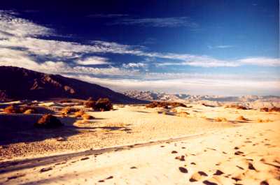 Death Valley Vista
6th, seems as if there's only so much of this commingling with Nature that I can take before I need to sit down in a paved parking lot outside a shopping center tearing into a double dip apricot mango ice cream. Fortunately, Boulder City, Nevada, nips this crisis in the cone. We continue to California, Palm Springs, where Frank Sinatra Drive almost but not quite intersects with Bob Hope Road, and on to Hermit, where Jane stops to inspect some horse farm product. But this is OK, because later we score a free bed & breakfast at some friends of hers in Hollywood. Hollywood! What can I do here!? Well, leave, for one thing. I drive to Santa Monica to see Lynn Dally, a long time tap dancing friend who's company is an impressive 22,000 bucks in the red, plus one of her star dancers is recovering form back surgery--you know, it's those little things in life that irk you. A group of dancers and a piano inspire me to whip through an improv with them, and later we repair to a Hollywood caf� to await the second coming of lasagna.
8th, Jane & I zoom north to Visalia, where more horse product piques Jane's interest and the Eagle Snacks corporate headquarters piques mine. Now west along a circuitous road to a Morrow Bay grocery for resupply, and north along the Pacific Coast Highway to a state park in which to savor our selections. Next morning, continuing up the coast, we pause to explore Big Sur, then Big Basin Redwood State Park. It's the scenic inverse of Grand Canyon: muted greens instead of reds, towering trees instead of cliff faces, the sky gray instead of deep blue. All right, maybe not the inverse; but pretty keen, nonetheless. We set up the tent in a shady glade surrounded by redwoods, eucalyptus, woodpeckers and deer. Somebody ought to make a recording of these sounds, sell 'em to frazzled humanoids, I think as I drowse. The gentle pitter patter of the first appreciable rain of the journey sends me over the REM edge and I sleep. And dream. I am on a waterbed. Suddenly, I wake up. I AM on a waterbed. We (I) unwittedly made camp in a basin, which the steady rain has turned into a pond. At least the crops are saved. North to Mendocino, where Jane has still more friends who have a big house a half mile from the ocean with a big clothesline on which to hang out the camp gear to dry after I've rinsed the branches and forest off it.
11th, too much morning dew, the campgear's still soaked. I set it out in the sun to dry; it rains. I leave Jane with her friends, continue north to Eureka, home of the rafters who gave us a lift through Granite Rapids, see if I can score a second ride. Even around town would do. But the answering machine says they're out of the office till January. I drive north. Twenty-five miles up the coast I spot the best crooked tree I've ever wanted to photograph, but lowering clouds and rain and darkness thwart my admittedly meager film skills. Aimless now, I stop in Crescent City, where howling 55 mph winds lull me to another motel snooze. Along the rugged Oregon coast, a steady onshore wind blows clouds off of the Pacific. I pass half a dozen state parks, many with satanic themes. I stop at Devil's Churn, a rocky inlet where thunderous waves pound the shore. Near a pile of boulders, I stoop to commune with a giant banana slug. North into the night, I price a couple of motels, but it seems to be a seller's market here. Moving on, I cross the bridge into Washington, pull into a roadside park, hope that this will be my final night of bothersome carnapping. In the morning, back on the interstate to Bremerton, a bay away from Seattle, visit a friend who transplanted herself from New Jersey en route to Hawaii.
14th, I take the ferry to Seattle, look up more friends who have moved-no-forwarding-address since I last visited, shop for oddities at famous Pike Street Market, a two-block long parade of produce stalls and electric wares. I buy three fish whistles, radish-shaped ocarinas with one-octave ranges. Why? I visit the regional office of the hamburger corporation, tastefully decorated in neon and large sculptured pigs, then catch the ferry back, beginning to think fondly of another canyon hike, certain it wasn't as hard on me as I recalled. I catch the ferry to Victoria, British Columbia, not so easy. It's 76 miles away and sails at 7:30. The seas are heavy and I feel definite stomach malfeasance as the boat rocks port to starboard to port to ... you get the idea. But I make it, and by 9:00 I'm wandering the nearly empty streets. Apparently, things don't start cooking till 10. Ahh, but how they do cook--the streets sizzle nicely in this quaint little Euro-city, so compact, easy to stroll around. I exchange $35 US for $42.39 Canadian, then spend it. I buy chocolate from a famous chocolate maker, tee-shirts from a famous tee-shirt manufacturer, biscuits from a famous biscuit street peddler. Having exhausted all but five cents of my new currency, I head for a free ogle of fantastic Indian totems at a museum, then meander back to the harbor to await the boat's return. I brought plenty of raingear to BC, but the skies, although plenty threatening, never consummated their bluff. Back in the US, I sneak the chocolate through customs, then drive back to Bremerton. And rain. Next day, more rain, the heavy, soaking kind. Good day for doing things of a non-scenic nature. Like interstate travel. Figuring Victoria was a good northern terminus for this trip, I head south. Not far, only 450 miles to Medford, Oregon, but far enough in the interminable rain. With funds low but on a chocolate high, I find a budget motel. The accommodations are beaten and dismal, but at least the next door construction site is quiet. Until the night crew shows up, that is.
17th, still raining. Ten miles south, the road begins a slick wind up to a 4,800' pass. Snow now, hard and driving. And hard driving. Can't see, but can feel the tire traction fading. But once on the downhill side, the snow is replaced by California. I drive to the San Francisco home of a dancer friend; since I left my S.F. map elsewhere, I find her house almost but not quite by accident. No one's home--I didn't phone ahead, of course--and I haven't been here in five years, so it's not likely I was expected. I sit down on the front step and write a note. Just as I finish, she pulls up and I'm discovered, invited in. I'm a bit disappointed; it was a great note. I explore the city, rediscover some old favorite haunts, find others razed. Then I'm taken to Price Club, wow, a discount warehouse with goods in giant quantities at seriously discounts, compelling you to purchase stuff you really don't need but may regret not having bought a year later. It works--I buy ... oh I'm just too ashamed to admit it. Later, we push furniture around the house in preparation for a large party.
20th, shortly after the party begins, I leave, drive south 423 miles to Garden Grove, a western terminus I've patronized in the past, friends I haven't seen in, oh, some time. Two hours later, I'm ready to leave again.
21st-26th, I don't leave.
27th, the Doo Dah Parade in Pasadena, glad I stayed.
December 3rd, 3:40 a.m., EARTHQUAKE! Why aren't people running around being upset?
12th, on my 41st birthday, I leave, head southeast. Through the Mojave Desert into Arizona, fighting an impulse to drive north to Grand Canyon, on to Tucson and beyond. On and on into West Texas to Marfa, then south to Big Bend National Park, and another free campground. No it isn't, the ranger patrol shows up in the early morning, elicits the $5.00 tenting cover charge. Feeling a need to air out my wallet a little, I shell out another $1.50 and take the shuttle to Mexico. Some shuttle, it's a leaky dory which some guy rows the forty-some feet across the two-foot deep Rio Grande to Boquillas. I wander around the town, snap a few pictures, chat with the storekeepers (Visa accepted), decide this is an acceptable southern terminus. The ride back to the states is fraught with peril--a horse attempts to drink the river water--then I get another backcountry permit, drive onto a narrow, rutted dirt path to a bluff which overlooks the river.
15th, time to wrap this baby up. I zoom out of Big Bend, stopping to shepherd a tarantula safely across the macadam, drive 814 miles north through an unending expanse of Texas rangeland to Amarillo.
16th, Just west of town, Cadillac Ranch, Americana half buried in a wheatfield, thanks to Ant Farm. You really ought to see this place.
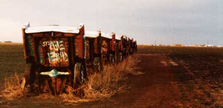 Cadillac Ranch
17th, 18th, 19th, east and a little north now, stopping briefly in Kentucky, Ohio and Carnegie Mellon University, the last to surprise Lynn, the tap dancer, who's supposed to be in residence here, who surprises me by not being there. At last, at 6:35 p.m., after 13,781 miles, Riverton, NJ, a more familiar terminus.
20th, I phone the corporation, tell them I've appreciated their patience while I mulled things over--and especially appreciating their voice mail system--but I quit. Shortly thereafter, so, too, does my voice mail password. Sure was fun while it lasted, though.
The Middle-Aged Hiker is Copyright ©1993-97,2002 by Dennis Báthory-Kitsz and David Gunn. All rights reserved.